Hiking in the Dolomites: Best Trails for Every Level
Hiking in the Dolomites sounds like something you need to train for. Serious boots, technical gear, a fitness baseline that doesn’t include chasing a two-and-a-half-year-old around a hotel room. I had all of those doubts when we were planning our trip. Then we spent a morning walking around Lago di Braies with our son in his toddler shoes, jaws dropping at every corner, and I realized the Dolomites have figured something out that most mountain destinations haven’t: you can access genuinely world-class scenery without being a serious hiker. The easy trails here aren’t consolation prizes. They’re the real thing.
This guide covers the full range — from flat lake circuits you can do in sandals to multi-day routes for people who actually know what an ice axe is. I’ll be honest about which ones I’ve done personally (we had one day, so the list is not long) and which ones I’m recommending based on careful research. If you’re still figuring out where to base yourself, the where to stay in the Dolomites guide and the Dolomites travel costs breakdown are worth reading first.
Quick answer: If this is your first Dolomites hiking trip, start with Lago di Braies for the easiest family-friendly walk, Tre Cime di Lavaredo for the classic postcard trail, and Seceda if you want huge views with cable car help. Book parking or lift tickets before peak-season days, start early, and treat even easy trails like mountain weather can change fast.
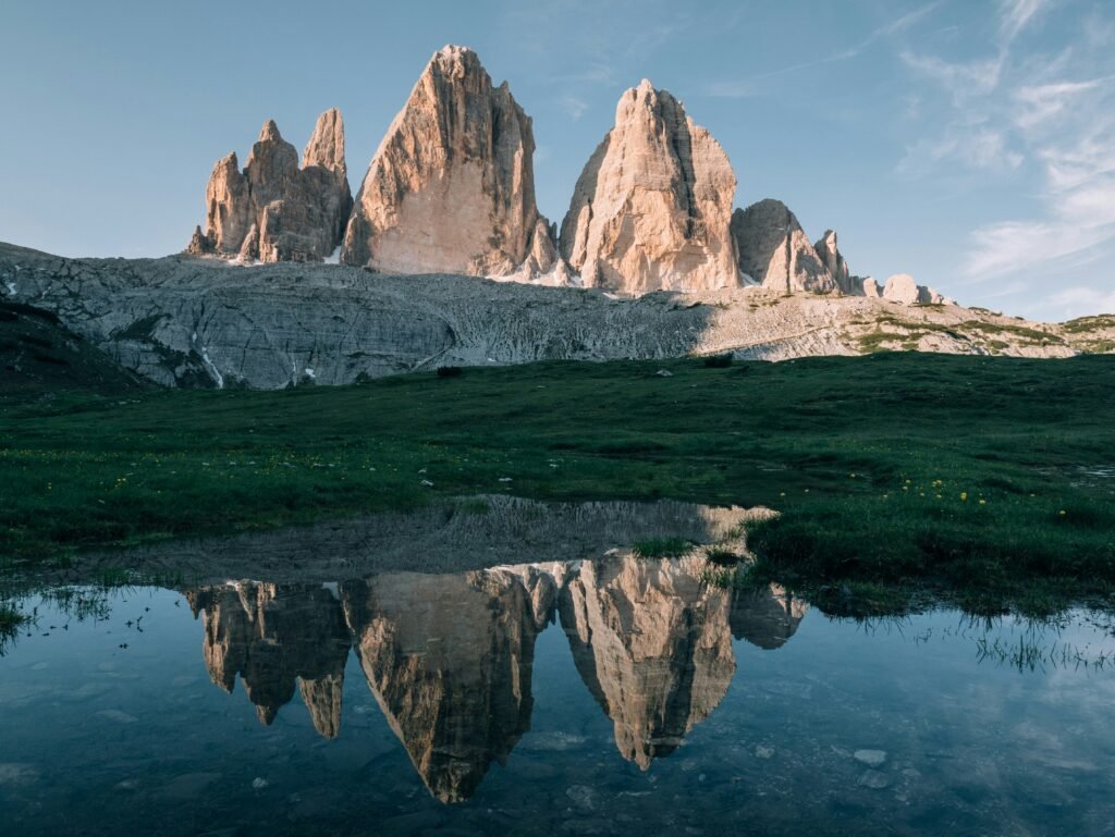
Table of Contents
This post contains affiliate links. If you book or buy something through them, I may earn a small commission — at no extra cost to you. I only recommend things we actually use and genuinely believe in.
Before you go — quick links
- Flights — compare routes on Google Flights or Skyscanner; nearest airports are Verona, Venice, or Innsbruck
- Where to stay — compare Dolomites hotels on Expedia or Booking.com
- Guided hikes — compare Dolomites walking tours on Viator, and read the itinerary carefully for cable car inclusions
- Planning order — use my how to plan a trip guide before you lock hotels, rental cars, and trail days
- Travel card — read the travel money card guide before relying on airport exchange desks or high-fee cards
- eSIM — the eSIM guide explains when an Italy eSIM is worth it for navigation; download your hiking routes offline too
- Insurance — compare policy wording from providers such as World Nomads, and check hiking, altitude, and rescue exclusions before buying
Trails at a Glance
| Trail | Difficulty | Distance | Why It’s Worth It |
|---|---|---|---|
| Lago di Braies circuit | Easy | 3.7 km / 2.3 mi | Flat, stunning turquoise lake, toddler-friendly |
| Seceda ridge walk | Easy | 4–5 km / 2.5–3.1 mi | Cable car access, dramatic ridge, big views fast |
| Tre Cime circular | Easy–Moderate | 9.5 km / 5.9 mi | The iconic Dolomites postcard, very accessible |
| Alpe di Siusi | Moderate | Varies | Vast high plateau, cable car access, rifugios everywhere |
| Cinque Torri | Easy–Moderate | 5–7 km / 3.1–4.3 mi | WWII history + surreal rock towers |
| Rifugio Nuvolau via Averau | Moderate | ~6 km / 3.7 mi | 360° summit views, achievable in half a day |
| Alta Via 1 | Challenging | ~120 km / 75 mi | The classic multi-day Dolomites traverse |
| Forcella Lavaredo | Challenging | ~12 km / 7.5 mi | Exposed pass above Tre Cime, for confident hikers |
The map below shows all eight trails and viewpoints by difficulty — green for easy, blue for moderate, red for challenging — so you can see where each one sits before you plan your days.
What to Know Before You Hike in the Dolomites
A few things that aren’t obvious until you’re actually there.
Trail Markings
The Dolomites use the Italian CAI (Club Alpino Italiano) numbering system. Trails are marked with red-and-white painted stripes on rocks, trees, and posts, and each trail has a number. When you download a map or see a signpost, it’ll say something like “CAI 6” or just “6.” This system is consistent and well-maintained on popular routes. Download your route in Komoot or AllTrails before you go, and do not rely on live signal alone above the valleys. If you use an eSIM, an Italian eSIM from Airalo can help with quick map checks between towns, but your actual hiking route should still be saved offline.
Rifugio Culture
Rifugios are mountain huts that serve food, drinks, and sometimes accommodation. They are not rustic survival shelters — they serve proper meals, cold beer, and some of the best pasta you’ll eat in Italy. Plan your hike around one. Lunch at a rifugio mid-trail is genuinely one of the better things you can do in the Dolomites, regardless of how far you’ve walked to get there. Some require reservations for food during peak season (July–August); check ahead.
Cable Cars as Legitimate Shortcuts
Taking a cable car up to start your hike is not cheating. It’s how a lot of locals do it, and it makes several otherwise demanding trails accessible to families and casual walkers. Seceda and Alpe di Siusi both benefit from cable car or gondola access, while Tre Cime depends more on the toll road or bus access to Rifugio Auronzo. Factor lifts into your budget: small return lifts can be moderate, but major routes are not cheap. For example, the official 2026 adult return ticket for Ortisei–Furnes–Seceda is €74, so check the current operator price before you build your itinerary around a cable car day.
Best Months
Late June through mid-September is the main hiking window. July and August are peak season — more crowds, higher prices, but everything is open including high-altitude rifugios. Late June and September are quieter, cooler, and often clearer. Snow can linger on higher passes into early June. For a full timing breakdown, see our guide on the best time to visit the Dolomites.
Gear Basics
For easy trails: comfortable walking shoes with grip. Trainers work on the lake circuits. For anything moderate: proper hiking boots with ankle support, non-negotiable. Weather changes fast — a packable rain jacket is essential even if it’s sunny at the trailhead. More on gear below.
Easy Hikes in the Dolomites (Great for Families and Beginners)
Lago di Braies (Pragser Wildsee) Circuit — 3.7 km / 2.3 mi, Flat
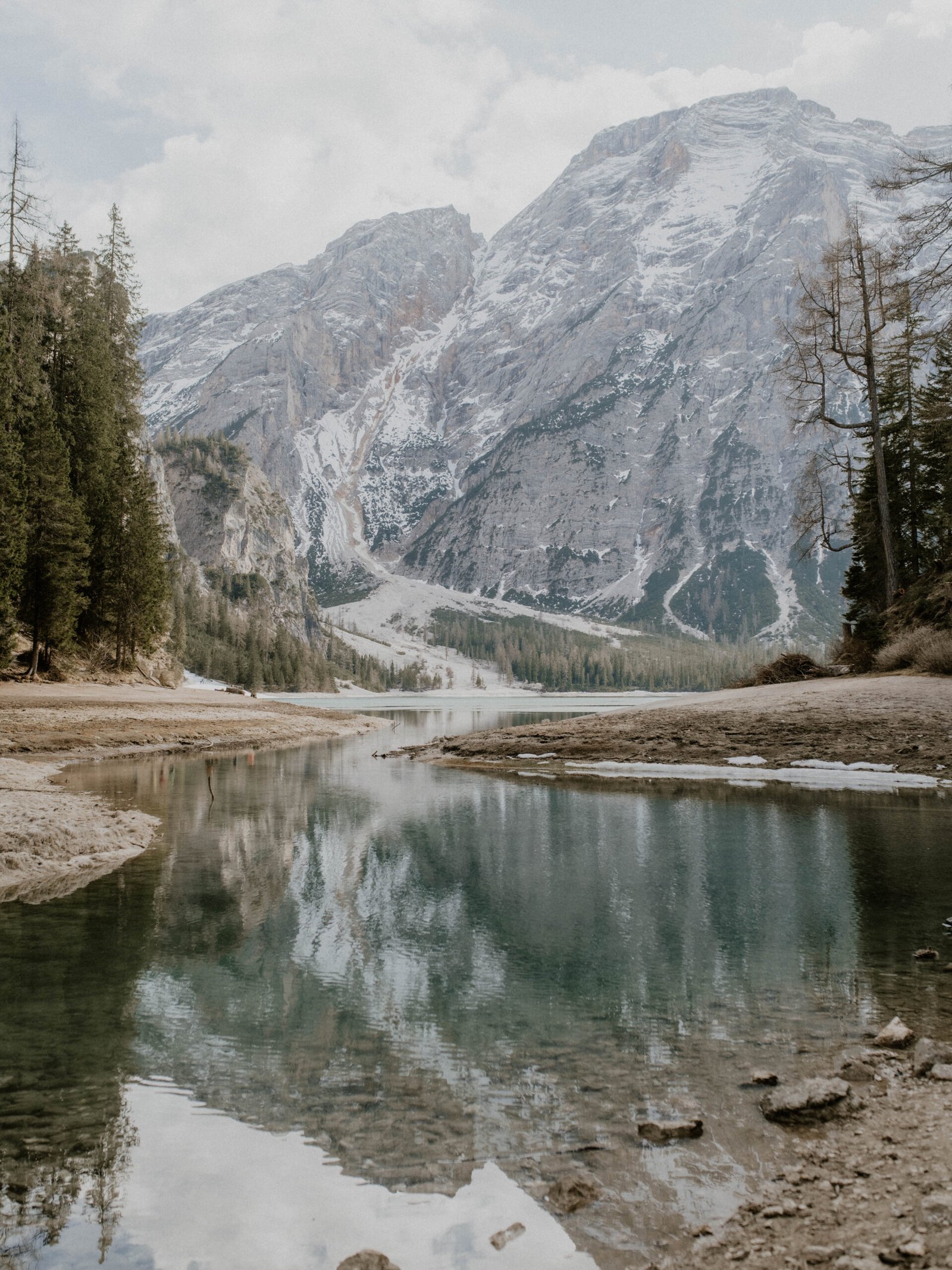
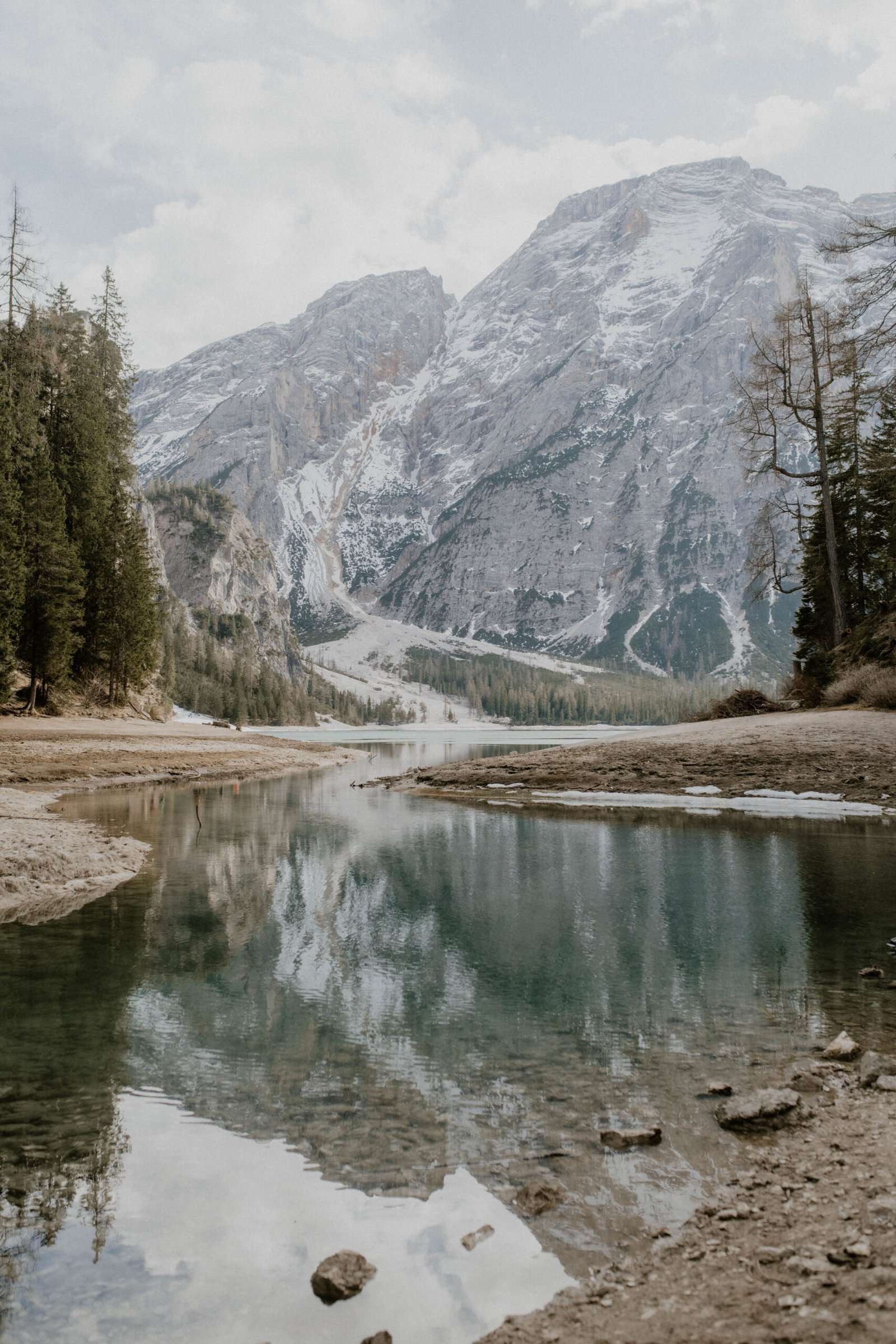
This is the one I can speak to directly. We did the Lago di Braies circuit on our single day in the Dolomites, with our son walking most of it himself — he was two and a half at the time. The trail circles the lake entirely. It’s 3.7 kilometers / 2.3 miles, almost completely flat, and the surface is good enough that a determined toddler can handle it without being carried the whole way. Some sections on the far side are slightly narrower and rockier, so watch your footing near the water, but nothing that felt unsafe.
The lake color is real. It looks edited in photos. In person it looks even more improbable — this deep glacial turquoise against the grey limestone walls. We were there in the morning and the light on the water was absurd. Even my husband, who is not someone who gets excited about scenery, stopped talking mid-sentence to look at it.
Practical notes: arrive before 9am or after 4pm if you are driving. For 2026, Lake Braies has mandatory access reservations from July 1 to September 15 between 9am and 4pm; without a valid parking or bus reservation during that window, you can be turned away at the access control. Outside those hours, access is easier, but only if parking is still available. There’s a rifugio at the lake (Rifugio Lago di Braies) where you can have breakfast or lunch with a view that most restaurants would charge twice as much for.
Seceda Ridge Walk — Cable Car Access, Mostly Flat Along the Ridge
I haven’t done this one personally, but it comes up consistently as one of the best easy-to-access viewpoints in the entire Dolomites, and the logistics make sense for families or anyone who wants maximum scenery for minimum effort.
You take the cable car from Ortisei (in Val Gardena) up to the Seceda plateau at around 2,500 meters / 8,200 feet. From the cable car station, the ridge walk to the main viewpoint is mostly flat or gently undulating — you’re not climbing, you’re walking along the top. The views are of the Geisler/Odle group, which are some of the most dramatic rock formations in the region: vertical grey needles rising from green meadows. It’s a legitimately stunning landscape that looks like a film set.
Round trip from the cable car to the main viewpoints is around 4–5 km / 2.5–3.1 miles. You can extend it by continuing along the ridge or descending to a rifugio for lunch. If you’re staying in Ortisei, compare accommodation options on Expedia or Booking.com; the right hotel can put you close to the Seceda cable car base.
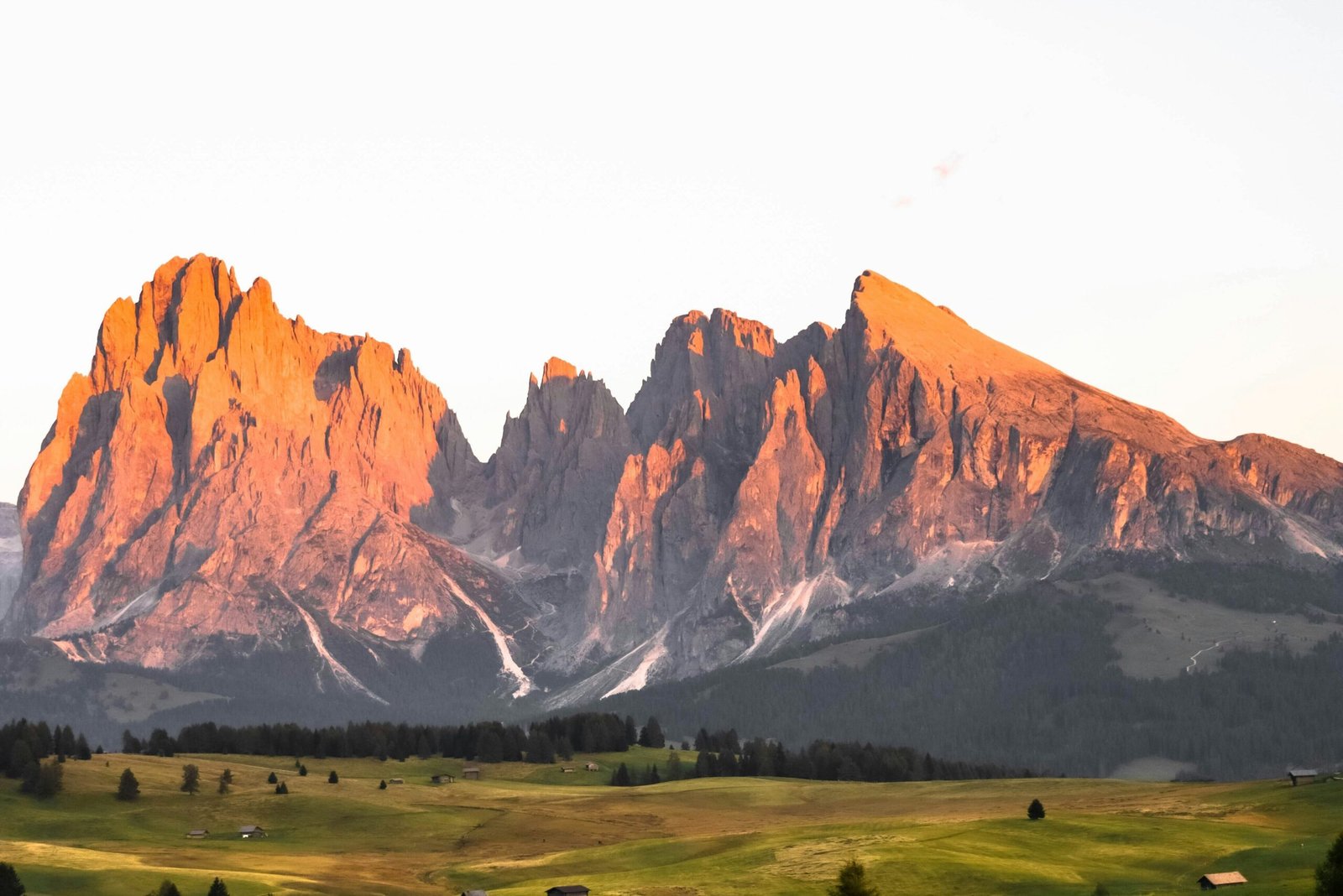
Tre Cime di Lavaredo Circular — 9.5 km, Easy to Moderate
This is the trail most people mean when they say “the Dolomites.” The three vertical rock towers — Tre Cime di Lavaredo — are the defining image of the region, and this circular trail takes you around them at close range. It’s 9.5 kilometers / 5.9 miles with around 500 meters / 1,640 feet of elevation gain. The gain is gradual and the path is well-maintained. It’s not flat, but it’s not technical. Fit beginners and families with older kids handle it regularly.
The trail starts from Rifugio Auronzo (2,333 meters / 7,654 feet), which you reach by toll road, shuttle, or bus depending on the season. For 2026, car access to the Rifugio Auronzo parking area requires an online reservation tied to your license plate, and the car rate is €40. From the rifugio it’s a clear, marked circuit. Plan 3–4 hours at a comfortable pace. There are two rifugios on the route where you can stop for food. I’d recommend the Rifugio Lavaredo side for lunch — it has a more dramatic backdrop.
If you want to stay nearby to hit the trail early before the crowds arrive, compare Misurina accommodation options on Expedia or Booking.com; it keeps you a short drive from the toll road base.
Moderate Hikes in the Dolomites
Alpe di Siusi (Seiser Alm) — Europe’s Largest High Alpine Meadow
Alpe di Siusi is a different kind of Dolomites experience. Instead of dramatic vertical rock, it’s a vast rolling plateau at around 1,800–2,000 meters / 5,900–6,560 feet, with the jagged peaks of the Sciliar massif and Sassolungo rising from the edges. The scale is odd — it doesn’t feel like you’re in the mountains until you look up.
You access it by cable car from Ortisei or Siusi, or by driving up outside the restricted road window. In summer, private car access is limited, and from June 15, 2026, parking reservations for P1 Spitzbühl and P2 Compatsch are required in advance. Once you’re up there, the trail network is enormous and the difficulty is mostly in how far you choose to go rather than how technical the terrain is. You can walk 3 kilometers / 1.9 miles between rifugios on a flat path, or you can do a 15-kilometer / 9.3-mile loop with significant ascent. The choice is entirely yours and there’s no wrong answer.
For moderate hikers: the loop around the plateau taking in Rifugio Compatsch, Rifugio Saltria, and the views toward Sassolungo is a full-day walk of around 12–14 km / 7.5–8.7 miles with manageable elevation. The rifugios here are genuinely good — this is a popular area with high standards.
Cinque Torri — Rock Formations, WWII History, Accessible Summit
The Cinque Torri (Five Towers) are a cluster of rock spires near Cortina d’Ampezzo that have been a climbing destination for over a century. The hiking trail around and between them is 5–7 km / 3.1–4.3 miles depending on your route, with around 200–300 meters / 650–985 feet of elevation gain. It falls in the easy-to-moderate range — there’s some climbing on rocky paths but nothing exposed or requiring hands.
What makes this trail interesting beyond the scenery is the World War I open-air museum at the top. The Dolomites were a frontline during WWI, and Cinque Torri has preserved trenches, shelters, and military installations that you can walk through. It adds a layer to the hike that’s genuinely worth paying attention to, not just a side note. The Rifugio Scoiattoli at the base of the towers has one of the better locations of any rifugio in the area — directly below the rock towers with a clear view of Cortina in the valley.
You can take a chairlift from Passo Falzarego to cut the approach, which makes it accessible as a half-day walk.
Rifugio Nuvolau via Averau — 360° Summit Views
Rifugio Nuvolau sits at 2,575 meters / 8,448 feet and is one of the oldest mountain huts in the Dolomites. The standard approach via the Averau col is around 6 km / 3.7 miles round trip from Passo Falzarego, with about 550 meters / 1,805 feet of elevation gain. It’s classified as moderate — the path is clear and marked but there’s a sustained climb and some rocky terrain near the top that asks for proper footwear.
The reward is a full 360° panorama: Marmolada (the Dolomites’ only glacier), Cortina d’Ampezzo in the valley below, the Cinque Torri towers, and on clear days, ranges deep into Austria. Plan 4–5 hours total. Start early to avoid afternoon thunderstorms, which develop fast at altitude in summer.
Challenging Hikes for Experienced Hikers
Alta Via 1 — The Classic Multi-Day Traverse
Alta Via 1 is approximately 120 kilometers / 75 miles of marked trail running north to south through the heart of the Dolomites, from Lago di Braies down to Belluno. It’s divided into roughly 10–12 stages and takes 8–12 days to complete. Elevation gain per day varies significantly, but the cumulative numbers are serious — this is a proper long-distance hiking route.
You stay in rifugios along the route, most of which need to be reserved months in advance for summer dates. The trail itself doesn’t involve technical climbing on most sections, but the daily distances and cumulative elevation make it suitable for experienced hikers with appropriate fitness. Some sections cross exposed terrain where a fear of heights would be a problem.
I’m including this because it’s the route people mean when they say they want to “do the Dolomites properly,” but it requires real planning. If you’re considering it, research the individual stages carefully — difficulty varies significantly day to day.
Forcella Lavaredo — The Exposed Pass Above Tre Cime
If you’ve done the Tre Cime circular and want more, route variants around Forcella Lavaredo can add steeper, rockier terrain above the standard path. Conditions and exact difficulty depend on which variant you choose, so do not treat this as the same kind of casual walk as the main loop. If a route description mentions fixed cables, via ferrata, or exposed scrambling, assume you need proper experience and gear rather than just good trainers.
This is not for people who aren’t comfortable with heights or loose rock. Some variants are hiking routes, while others move into via ferrata territory, so check the exact trail number and current conditions before you commit. The views from the higher passes are different from the circuit below: you’re looking directly down on the landscape you walked through, plus angles of the towers that most visitors never see.
Total distance including the Tre Cime circuit can add roughly 2–3 km / 1.2–1.9 miles and 300+ meters / 985+ feet of additional ascent, depending on the exact variant. Allow 5–6 hours total and skip it if weather is moving in.
Should You Book a Guided Hiking Tour?
For most of the trails listed here, you don’t need a guide. The marking is good, the paths are well-traveled, and AllTrails or Komoot will get you through without issues.
Where a guide genuinely adds value: if you’re doing a challenging route for the first time and want someone who knows how to read the weather and the terrain; if you want to go off the main trails and into less-visited areas; or if you’re visiting for a short time and want someone to make all the decisions about where to go based on conditions that day. Guides also know which rifugios are worth stopping at and which ones coast on their location.
If you want a guide, Viator has a wide range of Dolomites hiking tours — half-day walks around single landmarks up to full-day routes covering multiple areas. Read the itinerary carefully before booking; some tours include significant cable car time rather than trail time. For a second opinion on availability and pricing, GetYourGuide covers the same region and sometimes has smaller group sizes for the same routes.
What to Wear and Bring: A Practical Packing List
This list is calibrated for easy-to-moderate trails in summer. Adjust up for anything involving significant elevation or exposed terrain.
- Footwear: Hiking boots with ankle support for anything moderate or longer. Trail runners work for the lake circuits. Avoid flat-soled sneakers on anything rocky — the grip matters more than you think until you’re on a wet rock.
- Layers: Even in July, temperatures at 6,500+ feet (2,000+ m) can drop to 45–50°F (7–10°C) without warning. A lightweight fleece and a packable rain jacket take up almost no space and have saved a lot of afternoons.
- Sun protection: The combination of altitude and reflected light off rock is more intense than it looks. Sunscreen, sunglasses, and a hat — not optional.
- Water: At least 1.5 liters per person, more if it’s hot. You can refill at rifugios. Some trails have marked water sources; don’t count on them.
- Food: If you’re not planning a rifugio stop, bring real snacks. Energy bars are fine for pockets but a sandwich at a viewpoint is better.
- Navigation: Download your route offline before you leave the hotel. An Airalo Italy eSIM can help with occasional signal and town-to-town navigation, but it is not a substitute for offline trail maps.
- Cash: Some rifugios don’t take cards. €30–40 covers a simple lunch for two. For spending abroad, compare the Wise card for exchange-rate tools and lower-fee card payments, then still carry some cash for mountain huts.
- Trekking poles: Optional for flat trails, genuinely helpful on anything with significant descent. Your knees will have an opinion on this by hour four.
- Travel insurance: Non-negotiable when you’re hiking at altitude, especially with kids. Compare providers such as World Nomads, but read the policy wording carefully for hiking, altitude limits, mountain rescue, and evacuation before buying.
If you’re bringing a toddler: a carrier or hiking backpack carrier rather than a stroller for anything beyond lake circuits. The Lago di Braies circuit is an exception — we managed it on foot. A change of clothes for the child, more snacks than you think you need, and a strategy for the inevitable “I’m done walking” moment around kilometer 2.5 / mile 1.5.
Frequently Asked Questions
Is hiking in the Dolomites difficult?
It depends entirely on which trail you choose. The lake circuits — Lago di Braies, Lago di Carezza — are easy, flat, and suitable for almost anyone including young children. Moderate trails like the Tre Cime loop involve some elevation and rocky terrain but are well-marked and manageable with basic fitness. The simple Seceda viewpoint walk from the cable car is easy, but exposed variants, via ferrata routes, and anything graded high on CAI difficulty require proper hiking boots, route-finding ability, and experience with mountain terrain. Most visitors fall somewhere in the middle — pick a trail one grade below your comfort zone for your first day and go from there.
Do you need a guide to hike in the Dolomites?
No — most popular trails are well-signed with CAI markers and thoroughly documented on AllTrails and Komoot. A guide adds real value if you’re tackling a difficult or exposed route for the first time, want to go beyond the standard trails, or are short on time and want someone to make the day’s decisions based on current conditions. If that’s your situation, Viator has Dolomites guided hikes in half-day and full-day formats across different difficulty levels.
When is the best time to hike in the Dolomites?
Mid-June through mid-September is the main hiking season, with July and August being peak. Trails are fully accessible, rifugios are open, and the days are long. The trade-off is crowds — popular spots like Lago di Braies and Tre Cime are genuinely packed by 9am in high summer. Arriving at trailheads by 7:30–8am makes a significant difference. Late September into early October offers thinner crowds, autumn color, and cooler temperatures — one of the best times if your schedule allows.
Can you hike in the Dolomites with a toddler?
Yes, and it’s more manageable than it sounds. The lake circuits are stroller-friendly on most surfaces, and a hiking backpack carrier opens up the moderate trails. We did the Lago di Braies circuit with a toddler on foot — it works if you build in extra time and snack stops. The key is choosing the right trail: flat, short, and with something visually rewarding close to the start so the walk pays off before the “I’m done” moment arrives.
How do you get to the Dolomites without a car?
It’s possible but requires planning. Trains get you to gateway towns such as Bolzano, Dobbiaco/Toblach, and Calalzo, then regional buses connect onward to places like Cortina d’Ampezzo, Val Gardena, and some trailheads. In summer, the Dolomiti Bus network runs to some trailheads including Tre Cime. The challenge is timing — early morning buses are limited and cable car windows are narrow. A rental car gives you far more flexibility, especially for hitting trailheads before the crowds. If you’re driving from the west, the Milan to Dolomites road trip guide covers the route and logistics in full.
What gear do you actually need for hiking in the Dolomites?
For easy trails: comfortable walking shoes, sun protection, water, and layers — temperatures drop fast at altitude even in summer. For moderate trails: proper hiking boots with ankle support, trekking poles (optional but useful on descents), a packable rain jacket, and at least 1.5 liters / 50 oz of water per person. For challenging or exposed routes: add a helmet if there’s via ferrata involved, navigation downloaded offline, and travel insurance that covers your specific hiking activity and rescue scenario. The full packing list with specific recommendations is above in the gear section.
More Guides for Your Dolomites Trip
One day there taught me that you don’t need a week of hiking in the Dolomites to understand why people come back. You need one morning at the right lake, or one ridge walk at the right elevation, and the argument makes itself. Whether you’re walking around a turquoise lake with a toddler or doing a multi-day traverse with a full pack, the scenery is working hard on your behalf. That part, at least, you don’t have to earn.
- Not sure where to base yourself? → Where to stay in the Dolomites — breaks down which towns work best depending on your hiking priorities.
- Driving from the west? → Milan to Dolomites road trip — the full route with stops, timing, and what to skip.
- Working out your budget? → Dolomites travel costs — real numbers: parking, cable cars, rifugio lunch, what it actually costs per day.
- Trying to pick the right window? → Best time to visit the Dolomites — crowds, weather, and shoulder season trade-offs explained.
- Coming from Venice? → Day trip to the Dolomites from Venice — what’s realistic, what to prioritize, what to skip.